Automotive / Navigation
Garmin GPSMAP 10X2/12X2 Series User Manual
A comprehensive user guide for the Garmin GPSMAP 10X2/12X2 series chartplotters. This manual covers device operation, customization, navigation, sonar, radar, autopilot, and troubleshooting.
Table of contents
Manual images
Click an image to enlargeQuick guide from the manual
This manual provides essential instructions for operating the Garmin GPSMAP 10X2/12X2 series chartplotters. Users should ensure the device is correctly mounted and connected to power and necessary sensors (transducers, radar, NMEA 2000 network) before operation. The device supports various navigation, sonar, and autopilot features which can be customized via the main menu.
Device Overview
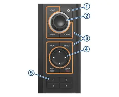
The device features a power button, a rotary knob for zooming and menu navigation, and dedicated keys for Home, Menu, Focus, Back, Select, Nav Info, and Mark/SOS. Connector ports include power, NMEA 2000, Ethernet (Garmin Marine Network), and transducer ports.
Customization
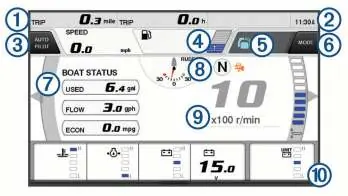
Users can customize the home screen, create favorite pages, and set up SmartMode layouts. The device allows for overlay data customization, background image changes, and setting up shortcut keys for frequently used pages.
Navigation
The chartplotter supports navigation using charts, waypoints, routes, and Auto Guidance. Users can create routes, follow tracks, and set up boundaries. Auto Guidance helps calculate the best route based on vessel settings and map data.
Sonar
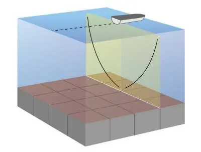
The device functions as a fishfinder when connected to a compatible transducer. It supports various views including Traditional, Garmin ClearVü, SideVü, and Panoptix. Users can adjust gain, range, and color intensity to optimize the sonar display.
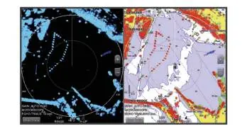
Radar
When connected to a compatible Garmin radar, the device can display radar overlays on charts. Features include MotionScope technology, guard zones, and MARPA for target tracking.
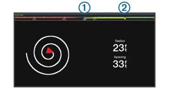
Autopilot
The chartplotter can control a compatible Garmin autopilot system. It supports heading hold, wind hold, and various preset patterns like circles, zigzags, and Williamson turns.
Troubleshooting
If the device fails to acquire GPS signals, ensure it has a clear view of the sky. If the device does not turn on, check the power cable fuse and ensure a 12V DC power supply is present. For further assistance, visit support.garmin.com.
Official resources from the manual
Manufacturer information
Garmin Ltd.
Practical help
Common problems
Device does not acquire GPS signals
Ensure the device has a clear view of the sky. If the device has been off for a long time, it may take longer to acquire satellites.
Device does not turn on or keeps shutting off
Check the fuse in the power cable. Ensure the device is receiving at least 12V DC power.
Waypoint not created in the correct location
Check that the map datum and position format settings match the map or chart being used.
Before use
- Ensure the device is securely mounted.
- Check all cable connections, including power and transducer.
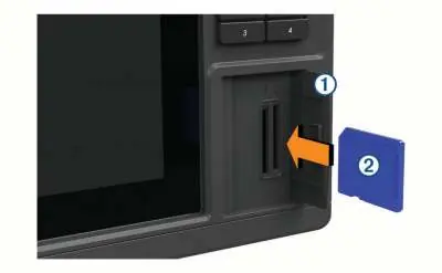
- Insert a compatible SD memory card (up to 32GB, FAT32).
- Ensure the GPS antenna has a clear view of the sky.
- Verify that the transducer is properly installed and connected.
Images and diagrams
- The device features a rotary knob for menu navigation and zooming.
- The connector panel includes specific ports for power, Ethernet, and transducers.
- Sonar screens display depth, fish targets, and bottom structure.
Model compatibility
- Requires a compatible transducer for sonar functionality.
- Requires NMEA 2000 network for autopilot and radar integration.
- Some features like Auto Guidance require premium map data.

Manual page author
Michael Turner
Technical manual editor
Reviews PDF manuals for structure, safety notes, and practical product details so readers can find the right information quickly.